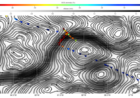
This marine currents map is unlike any other
Firstly, it is generated directly from our pre-operational processing chain and produced automatically in near real-time (NRT). eOdyn can now periodically produce reliable marine current data on an oceanic basin scale, covering all the world’s oceans.
Secondly, the map was produced using AIS data collected via coastal stations on the southern European coastline, without relying on AIS satellites. These real-time data, collected by coastal states and redirected to European regional servers and EMSA, demonstrate that infrastructure initially designed for maritime safety can now be used to observe the oceans in real-time.
Lastly, the total marine current product calculated in near real-time by eOdyn achieves an unprecedented level of spatio-temporal accuracy wherever there is human activity at sea.
This advancement marks the beginning of new challenges for eOdyn: powering services with significant environmental and societal impacts based on high-resolution spatio-temporal observed currents data. These include sea rescue, anti-pollution efforts, maritime routing, and the decarbonization of the sector. We are committed to meeting these challenges head-on.